Just what I wanted. Prompt delivery. I’m happy
Delivered in good time (2 weeks from manufacturers). Clean wood nice pole
I had them in quick time and easy to fit
West London Boat Service & Repair
Servicing
|
Boat Sales
|
Parts
|
Chandlery
01932 247 427
Imray
Ref: KHYOT0100
Couldn't load pickup availability
Next day delivery may be possible for this item: please call 01932 247 427.
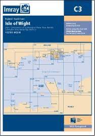
Durable to withstand sea conditions, this Imray chart of the The Isle of Wight makes plotting easier
A passage planning chart ideal for sailing near or around the Isle of Wight. Includes Needles Channel (1:35 000) Bembridge Harbour & Approaches (1:10 000). The chart is designed to be used alongside C15 The Solent for combined coastal navigation, approach, and harbour detail in and around the Solent and Isle of Wight. Minute Gridlines. Scale 1: 60,000.
Digitally printed on water resistant paper and folded inside plastic wallet. Imray charts are officially recognised by the Maritime and Coastguard Agency for use on coded and fishing vessels under 24m in length.
Printed April 2022: Latest correction notice available by scanning QR code
Product code: C3 Isle of Wight