Just what I wanted. Prompt delivery. I’m happy
Delivered in good time (2 weeks from manufacturers). Clean wood nice pole
I had them in quick time and easy to fit
West London Boat Service & Repair
Servicing
|
Boat Sales
|
Parts
|
Chandlery
01932 247 427
Imray
Ref: KHYOT0150
Couldn't load pickup availability
Next day delivery may be possible for this item: please call 01932 247 427.
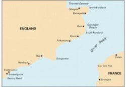
Durable to withstand sea conditions, this Imray chart of the Dover Strait from North Foreland to Beachy Head and Boulogne makes plotting easier.
Detailed coverage of the whole Dover Strait, showing the English coast from Beachy Head to North Foreland, and the French coast from Boulogne to Calais. Minute gridlines. Scale 1:120,000. Larger scale plans of Sovereign Harbour, Rye Harbour, Folkestone Harbour, Dover, River Stour Entrance, Ramsgate, Calais and Boulogne-sur-Mer.
Digitally printed on water resistant paper and folded inside plastic wallet. Imray charts are officially recognised by the Maritime and Coastguard Agency for use on coded and fishing vessels under 24m in length.
March 2022: Latest correction notice available by scanning QR code.
Product code: C8