I had them in quick time and easy to fit
Great product for use on a rusty Campervan, really does kill the rust and puts a varnish like coating on the surface to seal it.
West London Boat Service & Repair
Servicing
|
Boat Sales
|
Parts
|
Chandlery
01932 247 427
Navionics
Ref: NVL010-C1346-40
Couldn't load pickup availability
Next day delivery may be possible for this item: please call 01932 247 427.
Detailed coverage of major lakes and rivers of the UK and Ireland. Coverage includes the Thames, Medway, Mersey, Avon and Tweed Rivers in the UK and the Shannon River in Ireland. Lake coverage includes Lock Ness, Loch Lochy and Lough Neagh in the UK.
A comprehensive, all-in-one solution, Navionics+ charts and maps combine clear, reliable coastal/inland content with advanced guidance features and compatibility with a wide range of chartplotter brands.
Your purchase includes charts, maps and any content downloaded during the one-year subscription period. An active subscription is required to continue accessing new content such as daily updates after the included one-year ends.
Navionics+ and Navionics Platinum+ cards are not compatible with Garmin chartplotters. Check compatibility. If you own a Garmin chartplotter, you'll want Garmin Navionics+ charts.
ALL-IN-ONE MAP SOLUTION
Access detail-rich mapping of coastal features, lakes, rivers and more on a wide range of compatible chartplotters. Integrated coastal and inland lake content offers coverage for boaters worldwide.
DAILY CHART UPDATES
Charts are constantly being enhanced with new and amended content � thousands of updates are made every day. The included 1-year subscription gives you access to daily chart updates via the Navionics chart installer software.
DOCK-TO-DOCK ROUTE GUIDANCE
Advanced route guidance technology2 uses your boat settings, along with chart data and frequently travelled routes, to calculate a suggested path to follow from dock to dock.
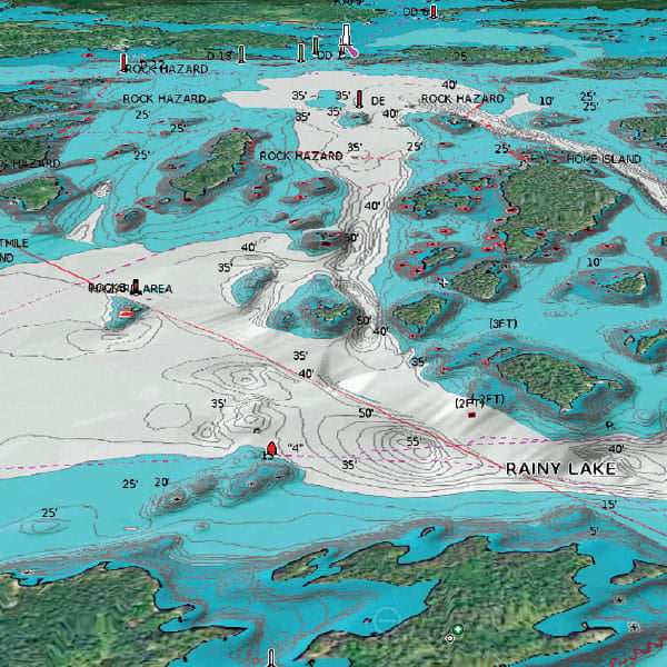
UP TO 0.5 M CONTOURS
For improved fishing and navigation, up to 0.5 m contours provide a clear depiction of bottom structure for fishing charts as well as enhanced detail in swamps, canals, harbours, marinas and more.
ADVANCED MAP OPTIONS
Change the way you view Navionics charts to focus on the details that matter most to you. Highlight shallow areas, adjust contour density, or select a fishing range.
COMMUNITY EDITS
Download community edits for useful local knowledge added by users of the Navionics Boating app, and view the data on your compatible chartplotter.
PLOTTER SYNC
Transfer routes and markers, update charts and more between your plotter card and mobile app � wirelessly. You can even activate or renew your cartography subscription and upload sonar logs4.